Himalaya Study Eyes How Urban Shifts Affect Land Uses and Natural Disasters
Using declassified satellite data, a Yale-led study will examine the links between urban growth, the frequency and magnitude of natural disasters, and economic vulnerability in mountainous towns of the Himalayan region.
By Kevin Dennehy
Note: Yale School of the Environment (YSE) was formerly known as the Yale School of Forestry & Environmental Studies (F&ES). News articles and events posted prior to July 1, 2020 refer to the School's name at that time.
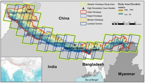
The Greater Himalaya Study Area will include a contiguous arc along the Himalayan mountains from the northwest Indian state of Jammu and Kashmir, through Himalayan Nepal, the Indian state of Sikkim, Himalayan Bhutan, and Arunachal Pradesh in northeastern India. High-resolution studies will also be conducted in three small towns (marked with triangles).
The Hindu Kush Himalayan region is home to an 800-mile mountain range that spans eight countries with more than 210 million people. It is also situated at the nexus of two critical trends facing mountainous regions worldwide: an increase in natural disasters and a surge in urban populations.
Yet there is little accurate information about the region’s changing urban populations, how their movements have changed the landscape, and how vulnerable these communities are to threats such as earthquake, landslides, fires, and floods.
A new Yale-led study, which will be funded by NASA, aims to provide clarity on these questions. Using a trove of remote sensing data — including declassified satellite images from the mid-20th century — the researchers will assess the change in urban settlements in recent decades, how those shifts have affected land use, the frequency and magnitude of natural disasters in the region, and just how sensitive the region’s socio-economic systems are to these stressors.
We don’t have up-to-date data on which towns are growing, how they are growing, and where the vulnerable people are located in this region.
— Karen Seto, Professor of Geography and Urbanization Science
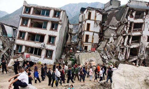
Such information wasn’t easily available in 2015 when an earthquake devastated parts of Nepal, triggering tens of thousands of landslides that buried whole villages in mud and rock. More than 9,000 people were killed and more than a half-million homes were destroyed.
“After the earthquake we started looking and realized that we had insufficient longitudinal data on how these towns and cities had been growing,” said Karen Seto, Professor of Geography and Urbanization Science at the Yale School of Forestry & Environmental Studies (F&ES) and principal investigator. “And it wasn’t just maps. We don’t have up-to-date data on which towns are growing, how they are growing, and where the vulnerable people are located in this region.”
“We have methods to detect the growth of big cities — that’s relatively easy,” she added. “But we have less macro-level data about smaller towns which are where most people in the Himalayan region are moving.”
The project will be conducted in partnership with the Yale Himalaya Initiative (YHI), the Kathmandu-based International Center for Integrated Mountain Development (ICIMOD) and researchers at the University of British Columbia in Vancouver, Canada.
From 1981 to 2000, the percentage of people living in cities and towns across the Himalayan region doubled. Depending on location, this shift was driven by multiple factors including the growth of the tourism economy, social and political unrest, and patterns of mobility causing rural families to relocate as a result of land degradation or changing abilities to maintain livelihoods.
This demographic shift has had significant environmental and ecological implications. Construction of new buildings, roadways cut into steep hillsides, deforestation, and unplanned urban development have caused a rise in hillside collapses, landslides, debris flows, and rock slides, putting millions of people at risk.
In the past few years alone, the Hindu Kush Himalayan region has experienced a 7.5 magnitude earthquake in Pakistan-Afghanistan; a glacial lake outburst flood in northern Bhutan; floods in Uttarakhand that killed nearly 6,000 and trapped 100,000 more; and the 2015 Nepal quakes that killed 9,000 and injured 23,000 more.
“These places are already very fragile and vulnerable to shocks,” said Alark Saxena ’07 M.E.M., ’15 Ph.D., an Associate Research Scientist at F&ES, program director of the YHI and co-investigator of the research project. “Forest fires, flash floods, earthquakes and landslides constantly affect communities in this region, and the impacts of climate change and human migration are only making them more vulnerable.”
Forest fires, flash floods, earthquakes and landslides constantly affect communities in this region, and the impacts of climate change and human migration are only making them more vulnerable.
— Karen Seto, Professor of Geography and Urbanization Science
“And because of this rapid urbanization, people sometimes establish themselves in areas that historically have not been conducive to habitation. If you add in these other environmental factors, such as climate change, some of these regions that were historically viable are now increasingly risky.”
Remote sensing offers the research team valuable new data on these trends from two distinct spatial perspectives. On the one hand, they plan to use archival Landsat satellite images to analyze the entire Greater Himalaya region, an area covering about 1.3 million square kilometers, at 30-meter resolution.
Also, to determine the accuracy of the Landsat analysis, they will initially study changes in three small towns — Leh, India (population, 27,500); Namche Bazaar, Nepal (1,600); and Trongsa, Bhutan (2,700) — at a 2.5-meter resolution. In addition to using high-resolution imagery for these sites, the research team will collect data on health, economic, and political conditions in these communities to support the socioeconomic analysis.
The towns were selected because of their small population size, relative remoteness from large cities, and geographic location.
Throughout the project the Yale researchers will work with partners in the region to assess the validity and reliability of the data collected.
“Satellite imaging doesn’t reveal how trade routes change or the demographic impact of political instability,” said co-investigator Mark Turin, Associate Professor of Anthropology at the University of British Columbia and Visiting Associate Professor at F&ES. “This project is an example of how collaborations that bring together bottom-up ethnographic knowledge with top-down big data can yield more nuanced understandings of social and environmental change than either one alone.”
Beyond providing better guidance on future development in the region, the researchers hope the findings will provide valuable insights to communities facing similar challenges in mountainous regions worldwide, from the Andes to the Caucuses.
One partner organization that will benefit from the insights is Lutheran World Relief, which has worked on breaking the cycle of poverty in India since the 1950s. Their current projects promote resilience and long-term development by preparing communities for natural hazards and helping families adapt to the impacts of climate change.
“This is a real opportunity to look at the confluence of urban development and vulnerability to earthquakes, floods, fires, and landslides,” Seto said. “It is important to understand where and how these settlements are changing — and what kinds of lands are being converted from agricultural use to urban settlement — because that affects vulnerability.
“And in places like the Himalayan region, it’s not a matter of if disasters will happen again. It’s a matter of when they will happen.”
Yale Himalaya Initiative Maps Risks in Post-Earthquake Nepal
In 2016, the F&ES-based Yale Himalaya Initiative completed a map of Nepal that highlights the risk for landslides across the entire country, and hopes it serves as a launching point for future collaborations with Himalaya-based organizations. <a href="http://environment.yale.edu/news/article/yale-himalaya-initiative-maps-risks-in-post-earthquake-nepal/">Read more</a>
Yale Responds to Earthquake: ‘Our Commitment Will Continue’
In an interview, Alark Saxena of the Yale Himalaya Initiative describes how Yale helped respond after the 2015 earthquake in Nepal — and how YHI’s longer-term mission will help make communities across the region more prepared for future threats. <a href="http://environment.yale.edu/news/article/yale-responds-to-nepal-earthquake/">Read more</a>
 The Greater Himalaya Study Area will include a contiguous arc along the Himalayan mountains from the northwest Indian state of Jammu and Kashmir, through Himalayan Nepal, the Indian state of Sikkim, Himalayan Bhutan, and Arunachal Pradesh in northeastern India. High-resolution studies will also be conducted in three small towns (marked with triangles).
 In 2016, the F&ES-based Yale Himalaya Initiative completed a map of Nepal that highlights the risk for landslides across the entire country, and hopes it serves as a launching point for future collaborations with Himalaya-based organizations. <a href="http://environment.yale.edu/news/article/yale-himalaya-initiative-maps-risks-in-post-earthquake-nepal/">Read more</a>
 In an interview, Alark Saxena of the Yale Himalaya Initiative describes how Yale helped respond after the 2015 earthquake in Nepal — and how YHI’s longer-term mission will help make communities across the region more prepared for future threats. <a href="http://environment.yale.edu/news/article/yale-responds-to-nepal-earthquake/">Read more</a>