Center for Earth Observation Turns 25 Amidst ‘Golden Age’ of Remote Sensing
At a time when Earth information is “more important than ever,” the Yale Center for Earth Observation is marking 25 years as the only Yale center exclusively devoted to remote sensing.
By Timothy Brown
Note: Yale School of the Environment (YSE) was formerly known as the Yale School of Forestry & Environmental Studies (F&ES). News articles and events posted prior to July 1, 2020 refer to the School's name at that time.
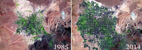
Two Landsat images (acquired in May, 1985 and May, 2014) use the same band combinations as the S0-Conn-FalseColor image so that vegetation is more visible. The brightest green areas are mostly golf courses. Vast expansion of the city is clearly visible — as is reduction of the nearby reservoir.
Over the past quarter-century, satellite-based remote sensing has changed the way we view the Earth and humanity’s impact on the environment. Remote sensing is now used to monitor a suite of atmospheric and surface conditions, from temperature, water vapor, and ocean currents to carbon dioxide concentrations, ozone, and cloud particle size. And currently about half of NASA’s funding goes into its Earth Science Program, developing and launching Earth observation satellites.
But for students and faculty interested in using remote sensing, there’s only one center at Yale exclusively devoted to remote sensing training and research — the Yale Center for Earth Observation(YCEO), which this year celebrates its 25th anniversary.
Xuhui Lee Takes Helm at YCEO
Xuhui Lee, the Sara Shallenberger Brown Professor of Meteorology at F&ES, was recently named director of the Yale Center for Earth Observation. Lee, whose research and teaching concern the interactions between the terrestrial biosphere, the atmosphere, and anthropogenic drivers, is also the Director of Yale-Tsinghua dual degree program, and recipient of the 2015 Award for Outstanding Achievement in Biometeorology from the American Meteorological Society.
“We’re in this golden age of information about the Earth at a time when it’s more important than ever to have that information because humans are beginning to really rapidly change our planet,” said founding director Ronald Smith, the Damon Wells Professor of Geology & Geophysics.
An atmospheric scientist who holds a dual appointment at the Yale School of Forestry & Environmental Studies (F&ES), Smith founded the center to assist others conducting research using remote sensing. After a quarter century at the helm, Smith is stepping down as director. Xuhui Lee, the Sara Shallenberger Brown Professor of Meteorology at F&ES has been named as his replacement.
“We have reached a milestone with the center,” Smith said. “We’re really proud of what we’ve done over the years, and I’m really happy that Professor Lee is going to take it over.”
In contrast to other universities that house their remote sensing lab within a specific department, Yale’s center, a project of the Yale Institute for Biospheric Studies (YIBS), is non-departmental. Students and faculty — from forestry and history, to public health and archeology — utilize the YCEO for remote sensing training and research.
In “Observing the Earth from Space,” the center’s flagship course, students learn how to identify which satellite data is best for a particular research project, where to find the data, and how to analyze it using powerful image processing software. Larry Bonneau, a research associate in the Department of Geology and Geophysics and YCEO manager, is in charge of day-to-day operations. He maintains the center’s 13 computers and software, which have been upgraded several times. But his primary focus is assisting both students and faculty with research.
“My biggest responsibility is to the users,” Bonneau said. “My real duty is to those people who come in and say, ‘Can satellites help me?’”
We’re in this golden age of information about the Earth at a time when it’s more important than ever to have that information.
— Ronald Smith, YCEO Founding Director
For many students, the course is their first foray into remote sensing.
“We’re really proud of what our students have done over the years,” he said. “Some of them have gone on to form remote sensing centers at other universities; some have gone on to use satellite images in their careers.”
“Without the YCEO I would not have completed my degree through Yale,” said David Butman ’06 M.E.Sc. ’12 Ph.D.
“My work was unique in that I was trying to utilize tools and methods from remote sensing of land use change, vegetation phenology, and climate indices of temperature and precipitation to understand the changing chemistry of the major rivers in the US,” he said. Now an assistant professorin Civil & Environmental Engineering and the School of Environmental and Forest Science at the University of Washington, he teaches an advanced remote sensing course modeled on the YCEO’s.
“The YCEO was critical to my professional path,” echoed Benjamin Zaitchik, an assistant professor in the Department of Earth and Planetary Sciences at Johns Hopkins University. “I arrived at Yale with virtually no remote sensing experience, but over the course of my graduate work I was guided by Ron, Larry, and other YCEO affiliates into a wide range of fascinating satellite applications.
“A key element of the YCEO approach is that satellite data are not just useful for monitoring environmental conditions — though they certainly are useful for that — but also as tools of earth system analysis that help us to understand how our planet operates,” he said. Zaitchik now uses remote sensing to improve seasonal hydrological forecasts in South Asia and East Africa, to study and monitor disease risk in the Amazon, and to track the impacts of climate and land management on water resources in the U.S.
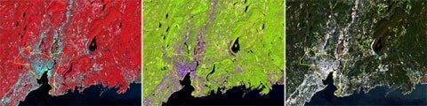
These Landsat images of southern Connecticut (including New Haven), acquired on September 30, 2013, are processed to show how changing the displayed bands (parts of the spectrum) can reveal more detail and features in the landscape. The image was subset to include portions of southern Connecticut around the city of New Haven (shown in yellow on these images). 1. <span style="font-size: 12px;">On the far left, the image is arranged using the near infrared, red, and green portions of the image data, and assigns these data layers to the red, green, and blue LEDs. This replicates what an image acquired using color infrared film would create. Vegetation appears red and urban areas cyan.</span> 2. In the center image, vegetation appears as bright green, conifers as dark, and urban areas as purple and dark blue. More variation is is visible. 3. <span style="font-size: 12px;">The natural color image (right) uses the red, green, and blue portions of the satellite image, producing a natural color image. These typically are dark with little contrast.</span>
“We teach many classes that become background knowledge for students and they are not necessarily aware that they are applying certain parts of their knowledge. With this class, it’s different,” said Lee. “You can see a direct link. When you take this class, it provides a new opportunity.”
“First and foremost, the YCEO taught me how remote sensing can be used to answer unique questions across large areas and in hard to reach places of the world,” said Colby Tucker ’15 M.E.Sc., who uses remote sensing to quantify the risk of PCBs to the endangered Hawaiian monk seal at the U.S. Environmental Protection Agency (EPA). “As one of the few employees at EPA Region 9 with experience with remote sensing, I am able to contribute to a unique project for the Agency,” said Colby Tucker.
The YCEO taught me how remote sensing can be used to answer unique questions across large areas and in hard to reach places of the world.
— Ronald Smith, YCEO Founding Director
As the new YCEO director, Lee is interested in expanding the program to include, for example, the use of drones, which can provide fine-scale detection for more localized planning.
“Satellites can only see large features on land, greater than 30 meters,” he said. “If you want to study a small pond or if you want to look at some minor topographic variation, those satellites won’t work for you. But if you bring in a drone, you can do that. You can even see individual plants; you can see minor topographic variations that are useful for disaster detection.”
Lee is also interested in better supporting the remote sensing needs of other courses, and making remote sensing an integral part of the summer training modules, or MODS, an orientation program for all incoming F&ES students. While about half of students who take the course are from F&ES, Bonneau says the center is a place where a mix of students from across the university can come together to learn, share, and support each other’s research.
“We’ve been working with all aspects of the university, a diverse group of people, for 25 years,” said Bonneau. “Helping to bring this technology to people, and helping to bring different people together.”
 Two Landsat images (acquired in May, 1985 and May, 2014) use the same band combinations as the S0-Conn-FalseColor image so that vegetation is more visible. The brightest green areas are mostly golf courses. Vast expansion of the city is clearly visible — as is reduction of the nearby reservoir.
 These Landsat images of southern Connecticut (including New Haven), acquired on September 30, 2013, are processed to show how changing the displayed bands (parts of the spectrum) can reveal more detail and features in the landscape. The image was subset to include portions of southern Connecticut around the city of New Haven (shown in yellow on these images). 1. <span style="font-size: 12px;">On the far left, the image is arranged using the near infrared, red, and green portions of the image data, and assigns these data layers to the red, green, and blue LEDs. This replicates what an image acquired using color infrared film would create. Vegetation appears red and urban areas cyan.</span> 2. In the center image, vegetation appears as bright green, conifers as dark, and urban areas as purple and dark blue. More variation is is visible. 3. <span style="font-size: 12px;">The natural color image (right) uses the red, green, and blue portions of the satellite image, producing a natural color image. These typically are dark with little contrast.</span>